
When it’s got to get done and got to be right, decision-makers and innovators in the public, private, and defense sectors turn to NOMADICS. Our full-service data analysis, technology solutions, and strategic interdisciplinary expertise have been trusted to solve complex problems and mitigate risk since 2006.
NOMADICS utilizes GIS and Information Technology (IT) to support our customers’ requirements, including but not limited to:
- Geospatial Data Services
- Geospatial Data Creation
- Cartography
- Geospatial Administration Support
Geospatial Data Services
- Discovery, collection, external research and validation, compilation, digitization, publishing, attribute inputs and updates, projection, transformation, georeferencing, mapping, archival, and quality assurance/quality control (QA/QC)
- Automated data lake draws from public, private, and government data sources, including Amazon Web Services (AWS), NTAD Data Lake and National Institute of Standards and Technology (NIST) Materials Data Curation System (MDCS)
- Identification of new data sources for collection, normalization, and integration (such as, social media, regional search query volumetric, foreign language international propagation indication sources, etc.)
- Cloud-hosted machine learning tools, such as Artificial Intelligence in AWS SageMaker and Lambda
- Complementary Data Repositories (CDRs) using AWS GovCloud
- Our unique cloud-native approach federates all data from its native locations while copying only limited or unique data sets into our CDR and customer Data Repository, leveraging existing customer storage investments
- Cross-domain interfaces, including bridging classified to unclassified networks
- Federation of data with a variety of AWS tools and services delivering actionable intelligence on classified networks

Geospatial Data Creation
- Development and management
- Performing Data Research & Data Collection Methods
- Remotely sense data collection for spatial intelligence
- Production of 2D/3D maps and models
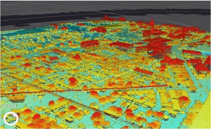
- Our hybrid data approach uses a combination of Photogrammetry, LiDAR data (Light Detection and Ranging), and RADAR acquired using aircrafts, ground based systems and electronic devises to create realistic 2- or 3-dimensional maps and models
- Accuracy within 5-25cm depending on methods and data sourcing
- Hybrid of geocoding approach for continuous cross-referencing verification and QA/QC maintenance
- Creating GEO Datasets and Appropriate Attributes
- Digitize, Code and Edit Points, Lines and Polygons (Entering and/or Updating Attribute Information)
- Project and Transform Spatial Raster and Vector Data
- Reformat, Geo-reference, and Rectify Spatial Vector
- GIS Parcel (Cadastral) Mapping
- Quality Assurance/Quality Control (QA/QC) and Validation of Spatial Data
Cartography
- Creation and application of maps to model, communicate spatial information, physically (static printed tangible maps) or digitally (static, dynamic, interactive and rendered in 2D/3D)
- General cartography and general audience maps for public dissemination
- Thematic cartography, theme oriented and designed for a specific purpose and audience
- GISP-certified team members for GIS management processes, ethics, education, experience, and contributions across the many facets of the GIS disciplines, which include Database Administration, GIS Administration, Programming, Digitizing/Data Entry, GPS Data Collection and Cartography
Geospatial Management and Administration Support
- Repeatable processes that account for scalability and adaptability to diverse, changing requirements
- Management of simple and complex, diverse multi-stakeholder requirements efficiently, effectively, and systematically into actionable scalable solutions
- Generate and maintain Work Breakdown Structures (WBS) that defines management process, resource allocation and stakeholder engagement based on the level of effort
- Our unique technical approach using Integrated Product Team (IPT) system design concepts is augmented by classical systems engineering methodology
- View requirements from a holistic Systems of Systems (SOS) perspective and ensure a full understanding of the moving and stationary components involved and the diverse stakeholder interests that drive or influence coordination
- Review mission requirements to ensure thorough understanding of the administration support requested and how to manage it
- Coordinate effective communication, establishing IPT frameworks that include meetings, schedules, tracking/progressing, and action items through closure of the support efforts
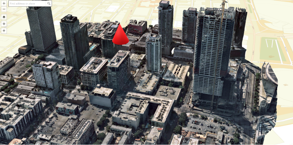
3D Services
Hypothetical problems are solved with non-hypothetical data. Our team of specialists balance powerful inputs with the intuition gleaned from real-world experience to develop accurate 3D models and expert analysis that reflect the built environment down to the centimeter.
- Light Detection and Ranging (LiDAR)
- Aerial Imagery
- Data Processing
- Topography Model Development
- Structure Model Development
- Underground Feature Model Development
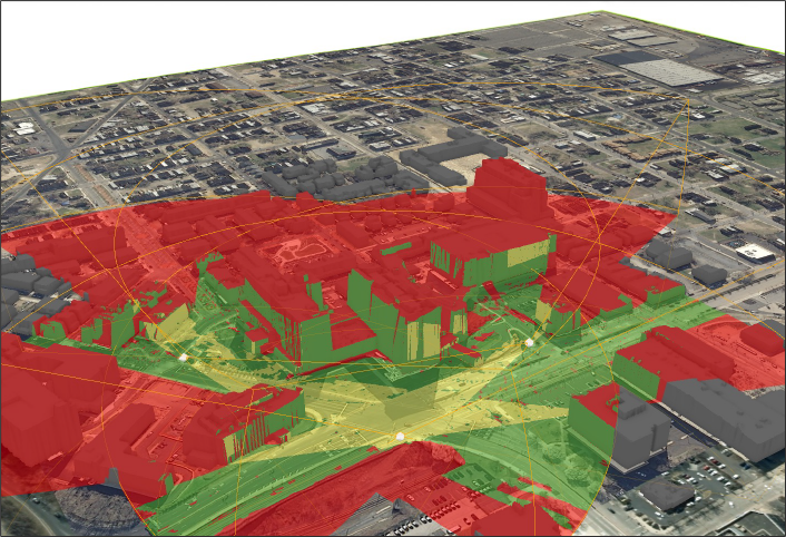
- Remote Sensing, Spatial, and 3D Analyses
- Viewshed Analysis
- 3D Model Maintenance
OTHER SERVICES + SOLUTIONS
Engineering and Technical Services
Follow NOMADICS to solve your complex problems. Our senior leaders and subject matter experts have used reliable geospatial data to create custom solutions in communications, logistics, transportation, defense, and development.
Research and Development
Follow NOMADICS to extend the state of what’s possible. Our on-staff subject matter experts and network of manufacturing partners can quickly develop and produce specialty and one-off components to aid in systems assembly and testing.
Partner with NOMADICS
Leading the Way for Progress
NOMADICS has created exceptional GIS data and technology solutions for dozens of innovators in public, private, and defense sector organizations across the United States and internationally.
The Nomad Group, LLC doing business as NOMADICS (CAGE Code 819L6 // DUNS 82-795-9151) is a small business concern, specializing in science, engineering and technology consulting services.
| NAICS 541330 | Engineering Services |
| NAICS 541360 | Geophysical Surveying and Mapping Services |
| NAICS 541370 | Surveying and Mapping (except Geophysical) Services |
| NAICS 541511 | Custom Computer Programming Services |
| NAICS 541512 | Computer Systems Design Services |
| NAICS 541519 | Other Computer Related Services |
| NAICS 541611 | Administrative Management and General Management Consulting Services |
| NAICS 541614 | Process, Physical Distribution, and Logistics Consulting Services |
| NAICS 541690 | Other Scientific and Technical Consulting Services |
| NAICS 541715 | Research and Development in the Physical, Engineering, and Life Sciences (except Nanotechnology and Biotechnology) |