
In 2010, NOMADICS worked with British Petroleum (BP), the USAF, USCG, USACE, USEPA, USDOI, USFWS, FEMA, and the state, county, and local governments of Florida, Alabama, Mississippi, Louisiana, and Texas with private contractors to coordinate and develop the emergency response and hazard mitigation, protection, recovery and rehabilitation strategies in the wake of the BP Deepwater Horizon industrial disaster.
In partnership with the United States Coast Guard, BP, and private contractors, NOMADICS was able to coordinate and develop the protection, recovery and rehabilitation strategies including but not limited to: daily development and/or analysis and/or utilization of data and projections for situation overview maps, strategic boom placement and removal operations maps, public information officer maps, subsurface oil assessment project (Ponar, Fluorometer, Sorbent Probe, Snare Sentinel, and V.I.P.E.R.S. [Vessels with Intrinsic Petroleum Ensnaring and Recovery Systems]) maps, air operations maps, S.C.A.T. (Shoreline Clean up Assessment Teams) track location and monitor status of onshore protection/cleanup operation and plume maps, and safe travel, stranded vessel, safe harbor strategy for rapid assessment teams.
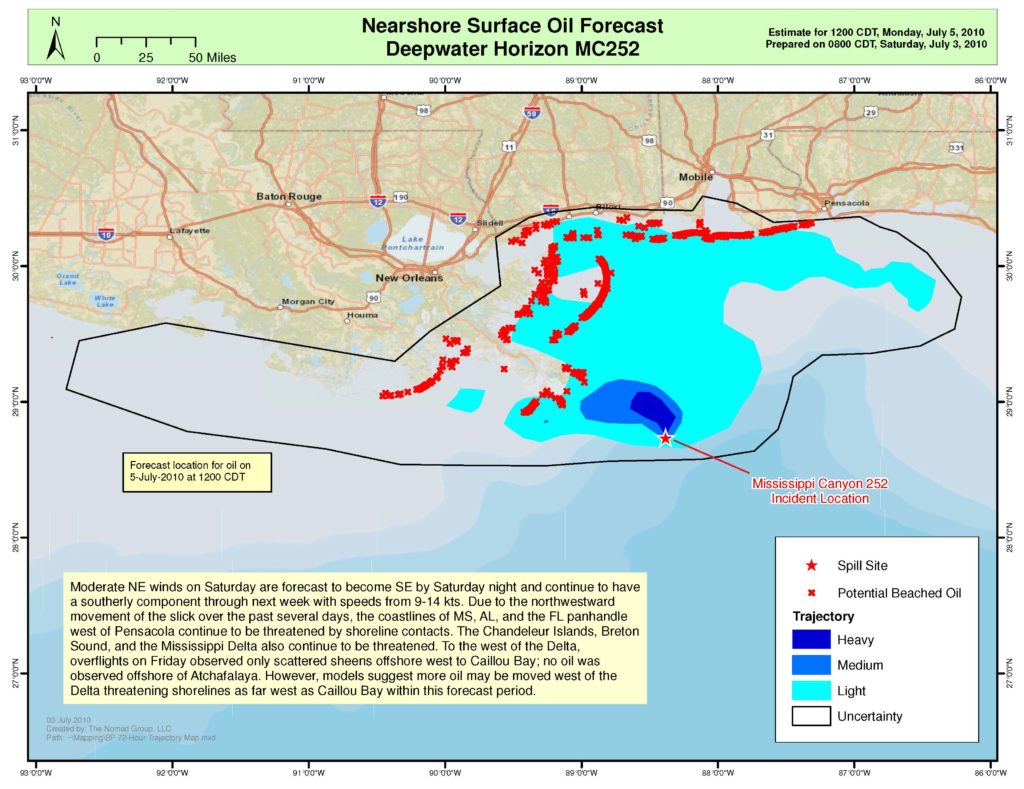
NOMADICS forecasted the locations of surface oil, within the Gulf of Mexico and along its shores on a daily basis. These maps were created to assist in the offshore cleanup operations. The surveyed areas and their attributes would automatically be displayed in an overall viewer that would allow for response leaders to track response progress, determine future cleanup planning and asset allocations, coordinate personnel movement, maintain a living history of contamination landfall and response operations, and provide an active communication channel with live updates to unified command.
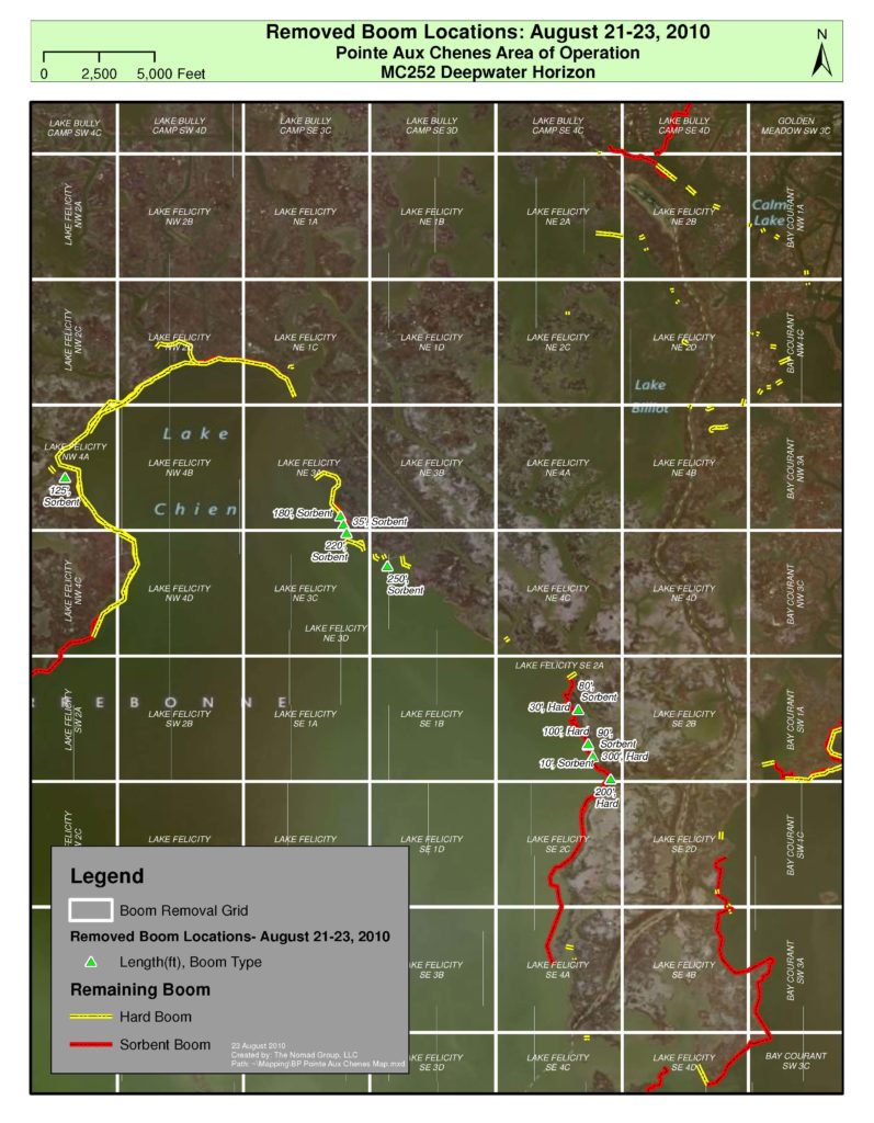
Our team also mapped the locations where contaminated boom was removed between August 21 and 23, 2010 and where it still remained—in relation with the boom removal grid—within the Pointe Aux Chenes, Louisiana Forward Operating Base (FOB) area of responsibility.
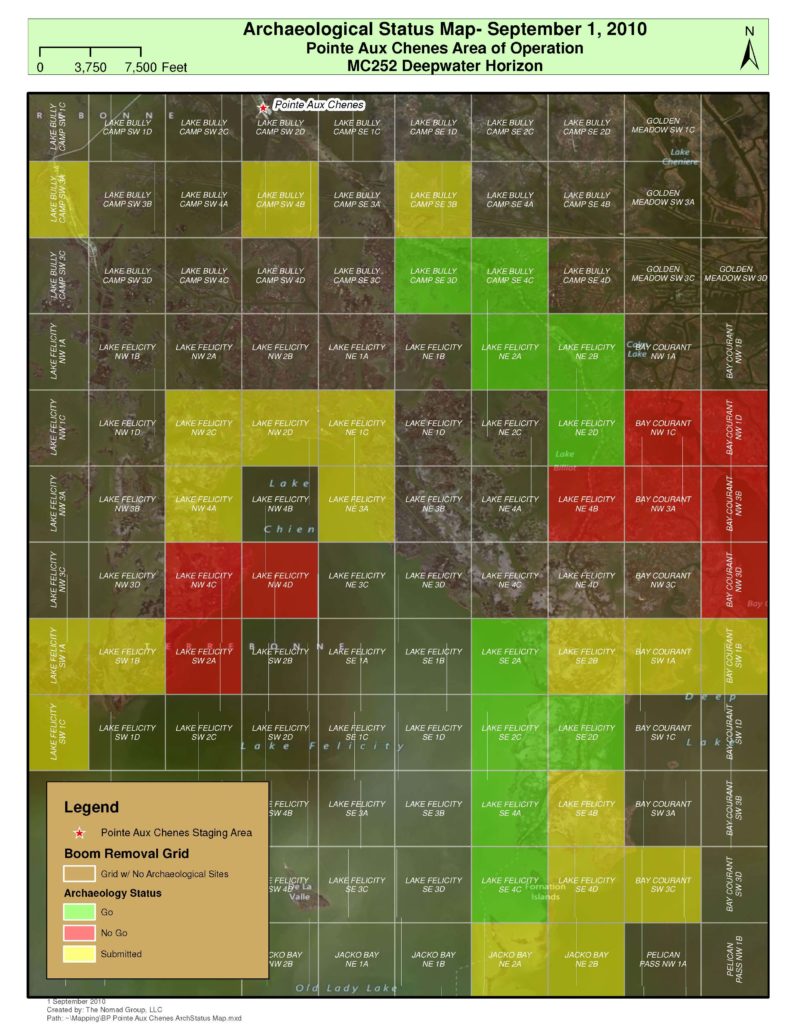
Similarly, this map depicts the archaeological status of the BP Deepwater Horizon MC 252 Response boom removal grids on September 1, 2010 within the Pointe Aux Chenes, Louisiana Area of Operation, in which the blank grids indicate the absence of archaeological sites and colored grids indicate the presence of archaeological sites. The colored grids were divided into three categories, which were Go (green, grids with archaeological sites that can be accessed by response crews), No Go (red, grids with archaeological sites that cannot be accessed by response crews), and Submitted (yellow, grids with archaeological sites that have be reviewed to determine if response crews can access them).
Our data technicians incorporated NOAA NESDIS surface and forecast data of oil movements and NOAA NHC inclement weather data. We utilized Rapid Assessment Team GPS data for analysis and development to track, map, and confirm locations and movements of oil, sheen, tarballs, and ecologically sensitive areas impacted specifically from the Deepwater Horizon Incident and participated in daily command briefings.
Leading the way for the region to regain stability following the cleanup, NOMADICS incorporated EHS training and experience into Health & Safety Plans for hazardous waste remediation crews, field biologists, and GIS data collection specialists pertaining to daily land and open water boom deployment/collection (manual, shipboard, and tandem rotary wing aircraft), wildlife operations of collection, handling, transporting, cleaning and release of both oiled and non-oiled aquatic, terrestrial and avian wildlife, and collection of GIS field data in a range of local environments.